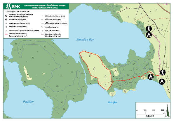
Jõemõisa hiking trail (0.5 km)
Jõgeva County, Tartu–Jõgeva Recreation Area
The 0.5 km forest path offers a fascinating walk for visitors of the recreation area. Those who wish to continue their hike can walk the 3 km Tammeluha hiking trail.
| Phone | +372 676 7030 |
| info.elistvere@rmk.ee | |
| Type of object | Hiking trail |
| Parking facilities | Parking at the Jõemõisa campfire site or in Tammeluha parking area. |
| Amenities | Indication and signs |
| Camping facilities | Jõemõisa campfire site, Tammeluha campfire site, Kalamehe campfire site |
| Outdoor fireplace | yes |
| Campfire site | yes |
| Hiking options | Tammeluha hiking trail (3 km) |
| Sights | The varied kame landscape of Kaiu |
| Additional information |
Before going on a nature walk please read the Environmental code of conduct (freedom to roam), rules of conduct and waste-sorting policy
|
| Restrictions |
The hiking trail is situated in Kääpa Landscape Protection Area (Tammeluha limited management zone). Waterways of the protected area are restricted to non-motorised boating.
Camping and making campfire is allowed in designated places only. Planning public events with more than 20 participants and using motorised vehicles on the waters of the protected area requires prior consent from the protected area manager. Additional information from the Environmental Board: +372 662 5999 info@keskkonnaamet.ee. |
| Location | Mustvee Municipality, Jõgeva County Object no 39 on recreation area map |
| Driving directions | Drive 33 km from Tartu on Jõhvi–Tartu–Valga road (Road no. 3) towards Jõhvi, turn right towards Pala–Kodavere, 3 km after the Kaiu bus stop turn right onto the forest road (RMK signs). Drive 600 m, turn right (follow the sign to RMK campfire site). The trail starts after 100 m, immediately before the campfire site (follow the sign to the left). |
| Geographic coordinates | Long-Lat WGS 84 latitude: 58.652682 longitude: 26.843752 |
| L-EST 97 x: 6504928 y: 665028 |
Click on the map to download it.
(The file is large, therefore the download takes a few minutes.)

